.comment-link {margin-left:.6em;}

canoeing, kayaking and other adventures

canoeing and kayaking adventures born in the Southeastern U.S. and now centered in Scotland...

Thursday, March 31, 2005

Okefenokee Swamp Part 1: The Long Slog To Camp

From one adventure to the next.... The following is the invite that I sent out to everyone to see who we thought might want to join us for the Okefenokee adventure.

Ever wanted to pet an alligator?

Lucas got a permit for the Okefenokee NWR late next month, for three days on the purple trail. We would launch on Sunday, March 27 and takeout on Tuesday, March 29. This is the peak time for the swamp, as all sorts of pretty things will be in bloom. Why were we able to get a permit with so little effort or notice? Probably because the launch date is Easter Sunday.

We are looking for 4-6 people to join us for this trip. The cost is $20/person plus a small launch fee to the NWR people, and shared food expenses. The $20/person is due by the 12th. So.... If you would like to join us for the trip, we would need a financial committment in the next few days.

The Okefenokee NWR has a no pets policy because pets look and smell a lot like food to an alligator.

If you would like to join us for the trip, or would like more information about the trip, please feel free to call me or email. Because of the time crunch, I'm sending this to a lot more people than can fit at our campsites. If you want a spot, speak up quickly.


After no less than six people cancelled on us, four of us set out on March 26 for a swamp daytrip on Saturday and then the Wilderness trip on Sunday through Tuesday.

Mapquest called it a 9 hour drive from Nashville to Fargo, GA (the nearest town to the park). Where Mapquest is usually conservative with their time estimates, Friday traffic made Mapquest into a blind optimist. Including stops for dinner, gas, an ill-fated attempt to find a place to sleep, and traffic at nearly every major city along our route, we drove for 12 hours to get to our campground.

We stayed at Griffis Camp near Stephen C. Foster State Park at the Southwest entrance to the park. Whereas the state park closes at 7:30pm, as in campers locked out or locked in closed, Griffis doesn't care when you get there. Their camp dog was very friendly, even at 3am. Unfortunately, so were their mosquitos. By morning, the welcoming committee was poised between our tent and rainfly, ready to greet us at the first zzzzip.

Sunday, March 20, 2005

Emory River -- Nemo to Camp Austin

Winter clinic is just a one day thing, with meals, education and entertainment provided Saturday morning and evening and Sunday morning. They have a board for trips going out on Sunday. Lucas and I signed up to lead a trip on a Class II/II+ section of the Emory River. Ours was the only one on the board. Other trips were going out, but nothing "official".

Several of the people from my BSF class (Kelly, Ginger and Steve) joined us, as well as the photo ring leader Jim. It was a beautiful, sunny day and the level seemed like it would be pretty nice. The shuttle was as long as I remembered it (I think that's why more people don't run Nemo to Camp Austin). We put on a little bit after noon and promptly two of us swam Nemo rapid. A few rapids later, we upped the swim tally to include all of the female members of the group.

We had a fun time, with the sun shining overhead and the play opportunities more plentiful than I remembered. We spent about four hours on the river, playing everything we could find. The pools between rapids got a little long toward the end. I think I enjoy them more in a canoe than in a kayak, but perhaps that's because I'm a bit more frazzled in the canoe still, and I'm completely focused on survival.


enjoying a spring day on the Emory


Lucas surfs

Big South Fork, rookie style

I wasn't sure what level to sign up as for Winter Clinic. I'm most of the way between Intermediate I and Intermediate II, but with the cold weather and the potential for no warm rocks to crawl onto, I decided to step down to Intermediate I for the clinic. It was a good decision and a bad decision. Good because it was useful. Bad because there were things I wanted to work on that we didn't. I guess the end result a realization that this and future clinics are not going to be as earth shattering for me as the clinics I took as a wide-eyed beginner. Now I need to work on the little things: technique subtleties, body mechanics, and most importantly learning to chill.

I can tell people I've been on the Big South Fork now. We put in at Jake's Hole and hammered on technique during the day. Then we picked apart the rapid below it (including doing some fishing with the rescue ropes), ran it one ducky after another, and packed up to head back to camp. Yes, one rapid. That's it.

Gosh that reads like a complaint, but really it isn't. I'm not going to take as many of the clinics anymore, but that's just growing up. Next time I sign up for winter clinic, it'll be with a group that runs more of the BSF. I wasn't emotionally ready for that at this clinic, but I know what I need to do if I want to get there.

Friday, March 18, 2005

anticipation....

Next up, TSRA's Winter Paddling Clinic. I leave in a few hours. My friend Kelly called last night. She said that we might get on something new, like Clear Fork. I like new rivers. :) There's a II/III section that sounds a bit like Jett to Lilly. I've never seen anything in the neighborhood of the Big South Fork. I'm looking forward to it.

Mulberry Fork of the Warrior River, AL (3/12/05-3/13/05)

So last minute, I stumbled across the information for the North Alabama Whitewater Festival. It was a first-time event held at the Locust Fork of the Warrior River. For $5/ea, it looked like a prime place to sleep and hangout between paddling trips. For a first time festival, they attracted a number of celebrities of the kayaking world. Team Jackson Kayak swept the pro men's rodeo and EJ's kids placed 1st and 3rd in the junior's rodeo. I know this because they did the awards on Saturday night, in between the LVM premier and some video propaganda for the boat manufacturers. Otherwise, I never would have known. Rodeo is an interesting thing and I do enjoy watching it, but generally my preferred venue for rodeo is on video on a weeknight. If it's a weekend and my boat is with me, I want to paddle.

The guy on the phone told me there would be trips headed out from the festival and all kinds of good stuff. Not so much. It was all about the rodeo. Which was fine. We enjoyed the misadventures on the boat ramp Saturday morning (where they slide down the ramp into the river and try not to eat it too badly) and decided the Mulberry would be the best way to not plow through the rodeo. Ender hole was the rodeo locale, just above the semi-legal Locust Fork takeout, so we would have to take out at Swann's or find a way to hike around them if we wanted to do the Locust. Mulberry sounded like a fine choice, so we headed to the putin.

By chance, we were able to hook up with a group of open boaters at the put in. I could tell they had been around for a while, and when somebody started asking one of the ladies in the group how many national championships she had won, I knew we were in the presence of old school greatness. It was a good day.

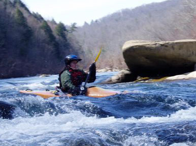
The weather was a bright, sunny, windy 75 degrees. The water level was just about a foot on the bridge, which made for a great level overall. I'm not sure what it was on the internet gauge. Not as big as the first time we paddled the river, not as scrapey as the second time we paddled it. I paddled my kayak, testing out my new pogies. I thought about trying my solo canoe, but decided I needed to remember what a kayak felt like. Lucas took the Caption. The wind was a bit pushy at times, especially with the canoes. Poor Lucas spent much time in the back, paddling that big boat by himself. I paddled with more of a sea kayak stroke on the flat stuff, high cadence but low power. That wasn't the best move for the rapids.

Lunch time was big, splashy fun. Others above and below were fun, too, but I don't know their names. It's only a 3mi run, but it feels as long as the Hiwassee. About the same number of rapids. The other ones we learned the names of were training wheel, a very forgiving side surfing hole that they weren't getting me into in the winter, and Mary's hole, a very unforgiving don't surf here hole near the end of the run. I'd love to lead a trip at the Mulberry sometime soon.

I could feel the fatigue of the work week. Awake til midnight every night has it's effect. My body might have felt like I was pushing it back toward dissertation mode. It was certainly rebelling against that idea. Not again! cried my sleepy eyelids. I found the dry line at 5-0 and decided I had enough for one day. I enjoyed watching everybody play, play, play, and got out the camera to take a few pictures.

We headed back for round 2 on Sunday, this time in the tandem canoe. No paddlers were at the put in even though the weather was gorgeous. Sunny & 75 again. We got our gear out and set up. I offered to run the shuttle, literally, after we paddled. It's 2-3mi, so it wouldn't be too bad. Lucas cheated. He asked one of the guys at the put-in, who was about to head out, if would take an extra few minutes to help us out. He did, and 20mins later, we were off.

The river was ours. Aside from a few people fishing at the top, we didn't see anyone until near the bottom. It was beautiful, serene. It had been a long time since we'd been in the Caption together, and I enjoyed the reminder of how awesome tandem paddling can be. Of course, I'm spoiled with an awesome tandem partner.

We were a little concerned about the water level, but that concern turned out to be unfounded. Everything was passable. We scraped maybe once or twice, but we do that anyway. Most of the lines were easy to hit. I guess I'm a kayaker at heart, because I like the big splashy lines even if they swamp the canoe. Did that a few times, not quite swamping, but collecting a decent amount of water. We didn't do a lot of eddy hopping, but we hit our lines really well. Without other paddlers, neither of us was anxious to try anything that might extract us from our boat.

I think the rapid with Mary's hole was better at lower water. The line is a series of big, splashy standing waves. We plowed through those, collecting some water. In the bow, I acted as a sieve for Lucas. I took the splash. The water pooled around his knees. It was warm enough that the surprise of cold water wasn't too overwhelming.... Still, we opted for the dry line at 5-0. It was a great way to end another awesome day on the river.

Black Creek Wild & Scenic River, MS (12/04-1/05)

From my article "Three Multi-Day Flatwater Trips within a Day’s Drive from Nashville...", in the TSRA Watershed...

Black Creek Wild & Scenic River in MS

difficulty: moderate

Putting in at Camp Dantzler bridge, the river is pretty narrow, about the width of a two-lane road. Houses along the banks overlook the river for the first few miles, giving the float that trespassy feeling. Strainers and mud rapids (large deposits of clay that looked and behaved like boulders) made for some challenging navigation. After the confluence with Big Creek, the river slowed and widened. Throughout the float to Fairley Bridge, the river narrowed and widened as more tributary creeks joined the flow. Clay “bluffs” followed the river banks periodically, a reminder of recent floods. Throughout the float, strainers resulting from the floods posed the biggest challenge. Tall pine trees lined the banks, ensuring occasional river-wide strainers even at the widest points. Wildlife sightings included a great blue heron, a beaver, wood ducks and an escaped domestic duck, deer, two wayward hunting dogs and several teenagers with an automatic rifle. We figured the ducks and the deer were in no grave danger the day we saw the teenagers.

For the backpackers and day hikers, Black Creek Wilderness Trail follows the river from Big Creek Landing to Fairley Bridge for a distance of 30 miles. Except for the areas with houses, the trail stays relatively close to the river.

The river is runnable pretty much year round. As long as river levels stay below 7ft on the USGS gauge, finding campsites along the river should not be difficult. Also, campgrounds are maintained by NFS at several access points. None are terribly large and many are right along fast roads, making more of a car camping atmosphere. Because Black Creek is a blackwater stream, you will need to pack in your own water, but you can access drinking water at the NFS campgrounds for refills if needed.

We used Black Creek Canoe Rental to run our shuttle. We ran 38 miles of this river, including the 21 mile Wild & Scenic section, over six days at the 2004/2005 confluence. The weather was warm and sunny... 60s and 70s during the day, 50s at night... so yes, you can paddle year round even if you don't like the cold. When in doubt, head south!

Escatawpa River, AL (11/04)

From my article "Three Multi-Day Flatwater Trips within a Day’s Drive from Nashville...", in the TSRA Watershed...

Escatawpa River in AL

difficulty: easy to moderate, depending on water levels

The Escatawpa River is a beautiful blackwater river that runs along the Alabama-Mississippi border near Mobile. Pine trees line the river banks, isolating the river rather quickly beyond the access points. Plenty of sand beaches offer numerous camping options. Hunting season gunfire and the occasional treestand were the only real signs of humans that we encountered between access points. At high water, paddling was easy. The river did all of the work. It took us about 2 hours to paddle/float our 7 mile objective for each day. Even at higher water, plenty of sandbars were available for camping. Because the Escatawpa is a blackwater river, we had to pack in our own water. Swimming is definitely an option for warmer months. A government study deemed this water quality to be among the highest for blackwater rivers. Unfortunately, encroaching development at some of the access points is causing erosion problems at the beaches near the access points.

We used Escatawpa Hollow Campground and Canoe Rental on US-98 to run our shuttle. We ran this river over the Thanksgiving holiday, putting in 21 miles above and paddling to the campground over the course of three days and a morning. An important note with this river is water levels can rise quickly in the event of rain. We had a heavy thunderstorm one morning and the water level rose several feet by the following morning.

Buffalo River, AR (10/04)

From my article "Three Multi-Day Flatwater Trips within a Day’s Drive from Nashville...", in the TSRA Watershed...

Buffalo National River in AR

difficulty: moderate
note: The USGS gauge for the middle to lower sections is not accurate. Recent flooding rearranged the streambed so that the gauge sits in a puddle of water that no longer correlates to the actual river conditions. Call an outfitter in the area or the NPS office to get an accurate assessment of river conditions.

Beautiful limestone bluffs follow the course of the river from its headwaters in the Boston Mountains, through the Ozarks and into the White River. Of the 150 miles, 135 miles are protected as a National River. The Buffalo River has everything from Class II/III whitewater to placid, deep pools. Whitewater transitions to flatwater as the river winds its way through the Ozarks. The section we paddled included the Lower Buffalo and Leatherwood Wilderness Areas leading up to the confluence with the White River. We spent a week on the river in early October, perfect timing to enjoy the Fall colors. Striking reds, oranges and yellows highlighted the bluffs. Days were warm and sunny, but not quite warm enough for swimming. Nights were cool enough that campfires never felt like overkill.

Information about the river says that lower sections can be run year-round, but the higher sections can be run only in the rainy season. This information is correct, mostly. At low water, expect you might have to get out and push through the occasional shallow section. Some small rapids will appear at these levels and you will need a keen eye to navigate them or sturdy footwear to correct your mistakes.

There are many outfitters that provide boat rental and shuttle service along the river. Check out the NPS website for a complete listing of outfitters that service each area.

Wednesday, March 09, 2005


The canine perspective of Forty Eight Creek


Demonstrating the Strainer Limbo on Forty Eight Creek

Monday, March 07, 2005

Bean’s Creek – February 19, 2005

It was a crisp February morning when at least 30 boaters converged on Falls Mill for Ernie Stewart’s float on Bean’s Creek. After the usual milling in the parking lot, we were treated to a full tour of the mill, including the big waterwheel. After the tour, we headed to the put-in nearby. Just about every form of plastic boat was represented. We had flatwater canoes and whitewater canoes, tandem and solo, whitewater kayaks and a touring kayak. We also had two swimmers of the canine variety.

The trip write-up promised “a swift Class I+ 10.5-mile float on a tributary of the Elk River through scenic hills of the Highland Rim.” Everything was true except for the swift part. The water level was low, so the first few miles were slow. Paddle, scrape, drag. Repeat. I’m sure we left plenty of painted rocks in our wake. The stream was slow enough that a couple of the river-wide strainers could be avoided with the boat limbo. Others required careful maneuvering. Still others got the chainsaw treatment from Ernie.

As soon as the stream became easy enough to paddle, we knew the dam (the scheduled portage) was near. River left offered a straightforward Class II portage. So ended mile 1.

Miles 2 and 3 continued in much the same manner. There were a couple of cascades that looked like they would be fun class I/II rapids with higher water. At our level, bumps and scrapes and occasional walks were the order of the day. We lunched somewhere around the end of mile 3, after Factory Creek (from the mill). Thanks to Ernie, we enjoyed a small campfire during our meal, but with over 7 miles to go, we knew we couldn’t enjoy it for too long. Because of the low water, the large group had split up some already. After lunch, the split became more official.

As more creeks flowed into Bean’s, paddling became easier. There were still plenty of scrape-y sections, but the odds of not having to get out and push increased greatly. The challenge became to read the water well enough to not have to step out of the boat. We were able to maintain a much more brisk pace. Since the chainsaw was behind us, there were two strainers that we decided to line our boats around. Everything else was runnable or scrape-able. Though the approaching sunset was on our minds, we made sure to enjoy the scenery around us. Critter sightings included fish, ducks and a great blue heron.

We saw some fishermen along the banks and asked how far to the bridge, which marked 1.5mi to our takeout. I don’t think they understood us, nor did we understand them, but the bridge turned out to be just around the bend by about a quarter mile. When we reached the bridge, the tension about the approaching sunset evaporated. We knew we had plenty of time to get there, and the groups behind us did, too. The bridge merited a stretch break. We reached the confluence with the Elk River and continued another half mile to our takeout. Other groups trickled in behind us. We all agreed, beautiful river but a bit like work to get to the bottom without enough water.

hello world: an idea begins to outgrow its britches

At the 2004/2005 confluence, we decided to start keeping a journal of our paddling trips. It was a last minute decision -- we picked up a spiral bound notebook in Brooklyn, MS, on our way to the put-in for a week-long trip. The notebook is filling up quickly. Between the multi-day canoe trips and the kayak day trips, I doubt we have enough paper to finish out the year.

Digital does not replace analog. The notebook and its successors will retain the place of honor in the dry box. They make dry bags for laptops, but that corruption has no place in the wilderness we seek. The laptop can wait for me at home. Entries here will be recasts of the on-river and post-trip journal entries. Digital can share the joys of analog, so that others can live vicariously through our adventures.

Of course, if you enjoy adventuring vicariously through my words, a donation could go a long way toward making the word job obsolete. For me, anyway.