.comment-link {margin-left:.6em;}

canoeing, kayaking and other adventures

canoeing and kayaking adventures born in the Southeastern U.S. and now centered in Scotland...

Tuesday, July 19, 2005

Tellico River – 7/17/05

Dodie, Mac, Lucas and I managed to coordinate a middle Tellico run with Diann and Woody despite the absence of flow information from the gauges. A lightning storm disabled the gauges sometime after Friday morning’s reading, so I asked my dad to interpolate based on past data and Jan at Creekside to confer with Diann and Woody. She also checked the rainfall in the area. Our best guess put us between 1ft and 1.5ft, skewing more toward the higher end because Crack in the Rock had the weird wave train instead of the ledge pool. It was definitely runnable, although scrapes would be inevitable.

Day 2 in the tandem boat started off much smoother than the first day. We had fun eddy hopping our way through the run. We even caught a surfing wave or two. I remembered many of the rapids from the previous runs, but they looked a bit different at this water level. Fake Crack in the Rock and the rocky wave train provided a nice warm-up to Crack in the Rock. Dodie tried to convince me the entrance was on the left, but at this water level, middle was the only runnable crack, even though it looked unconvincing at the entrance. Dodie conferred with Woody and then ran first. Mac followed, looking skeptically at the middle route until she remembered Woody’s instructions. After running the middle crack, she ran the rest of the rapid in at least one lazy circle before arriving in the pool below. Diann and Woody followed and then we ran, scraping along the right wall of the center crack and then made a valiant attempt to avoid Woody behind the big rock on river right. I have to wonder if Woody was able to snap a picture of the smiling fuzzy daisy as it attempted to impale him on the rock?

We ran a few more drops and then took a break for lunch before continuing onward. The next big hazard was a river-wide strainer above Flip Chute. We got there and I decided that I didn’t want to run it because of the strainer. Diann decided she didn’t want to run it because her usual line on river left wasn’t available. Dodie decided she didn’t want to hurt her back by landing on it funny. Mac decided to follow our example, so the boys ran the boats through. Woody ran first, bobbling a bit to the right on the landing. Lucas ran it perfectly in both the Caption and Mac’s Max, running it slightly left into the pool below. Woody ran it perfectly in Diann’s Probe. I felt pretty cool sitting with a rope at the bottom.

A few more rapids followed and then we reached Submarine rapid. Sadly, our vehicles were visible in the distance. We watched both Diann and Woody run the drops before running it ourselves. We chose Woody’s entrance, making a sharp right above the drop followed by a sharp left to run the drop. In a kayak, I have stern squirted out of this drop unintentionally. The Caption was a little big for that. We ran the line smoothly, landing in the pool below.

After loading the boats, we said our goodbyes at the takeout. Lucas and I stopped at the Ice Cream Run’s ice cream spot with Diann and Woody on the way home, one last treat on a treat-filled weekend.


the headless paddler strikes again

Clear Creek, Jett to Nemo – 7/16/05

Thank you, Hurricane Dennis! Although the Gulf Coast residents might not have appreciated your company, we appreciated the donuts you did between us and the Ohio Valley. The Plateau rose steadily over several days. The Oakdale gauge peaked sometime on Friday. Based on the weather patterns, I suspected the south side of I-40 saw more rainfall than the north side, so I put out feelers for possible trips on Emory River Canyon (north side), Whites Creek (south side) and Clear Creek (north side). Two basic groups formed. David Luinstra said he was going to paddle Clear Creek from Jett to Nemo. Bob Pierce said he and Jean were going to paddle either DBT to Nemo on the Obed or Lilly to Nemo on Clear Creek. Nobody experienced enough said they were interested in Emory River Canyon or Whites Creek, so we figured we would meet up with everybody at the Wartburg Visitor Center to see what options we had. Plenty of less experienced boaters expressed plenty of interest in our options, but neither was a stream where we felt comfortable leading a trip or helping others.

On the way to Wartburg, we learned that Emory River Canyon was out based on the water level. The Oakdale gauge had dropped well below the minimum of 2600cfs. Knowing what I know now about the water levels, even that minimum would have made for a tough run. Most of the water heading for Oakdale was coming by way of the Obed, which has the southern-most course of all three streams.

The trips got organized at Wartburg. We joined up with Luinstra’s Jett to Nemo trip, figuring that the Obed might be a tad much for our first solid class III in the tandem canoe. A number of familiar faces joined us. Experienced boaters included Trent, Craig, and Dodie Bush. Lilly to Nemo virgins included Chris Widick, King (a friend of Trent and Craig), Larry Cramer and Mac if she found her way to the group. She found us at the Jett Bridge access point while most of the drivers were still running shuttle and she presented me with a smiling fuzzy daisy to decorate the canoe.

Jett to Lilly was a nice warm-up for the bigger stuff that was scheduled to follow. It’s always awkward to get back into the tandem canoe when we’ve been paddling solo, either kayak or canoe. To ease the transition, we started the trip by talking to each other about each decision. It helped. We had a few mishaps that painted more than a few rocks along our path, but we made it to Lilly Bridge feeling much more comfortable than when we started, although still nervous for the bigger stuff that followed. For the first time, I think Lucas may have been more nervous than I was.

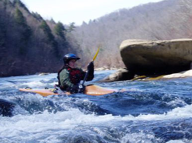
The Big Three come up pretty quickly after Lilly Bridge. Jack’s Rock Falls was first. It’s a bumpy approach to a rock slide into a friendly pool, provided you don’t get too far left or too far right. We watched Trent run it and decided we were ready to run it. The bumpy approach was bumpy enough for us to get stuck next to the little hump in the rocks that we were supposed to paddle over to hit the drop perfectly. On the bright side, we got a little bit extra time to scout the drop before running it. A few wiggles and shakes freed us and we hit the center of the drop, bobbling just a hair to the left as we landed. We caught the eddy below and I snapped a few pictures of the next few paddlers running the drop.

Next up was Camel Rock. I remembered not liking it all that much in the kayak. It’s a weird rocky drop on river right because river left has a pretty radical undercut. The last time Lucas ran it, the gauge at Lilly was reading over 600cfs. Our water level was well below half that. He remembered the pool below the funny drop as running into a big boulder. At our water level, the pool was still. We hit the drop clean, collecting a bit more water as we landed in the pool below.

A short paddle brought us to Wooten’s Folly, the most complicated on the run. The big entrance rock can be run either left or right. Left avoids the possible encounter with Barnett’s Rock on the right, but still kicks boats right when really they want to be on the left. The right entrance requires a hard left turn to avoid Barnett’s Rock but that turn sets boats up properly for the left route where the water runs. Luinstra ran us on the left. We hit the entrance drop perfectly, letting it wash us through a weird S that sure enough kicked us too far right. I yelled Left! Left! Left! as we struggled to get the boat far enough left to not pin on any of the rocks that followed. We made it and caught an eddy on the left to bail.

The nice thing about paddling tandem is all I have to do is paddle. All of the water pools around Lucas in the stern, so he gets to do the bailing.

We lunched below Wooten’s Folly and then set out to continue the run. On the Lilly to Nemo run, everybody talks about the Big Three, but more rapids follow before the Obed Confluence. I’m not sure which of the piles of rocks that followed was Rock Jumble, but we had probably another half mile of semi-continuous rock dodging and eddy hopping before we reached Focus Falls. Like a number of other rapids with “Falls” in the name, Focus Falls is more of a rock slide than a waterfall. It has a funny approach that culminates in a right to left slide into a moving pool, requiring an eddy turn or one last rock dodge before the friendly eddies below.

One more unnamed rapid followed before we reached the Obed confluence and the nature of the run changed. We went from intimate class III creeking to more open class III river-running. The rocks weren’t completely hidden, but the number of routes through each of the rapids opened up. We had more wave trains and holes and fewer pinning opportunities, but we didn’t let those escape us completely. At one of the rapids not far below the confluence, we took the far right route and had only a few options. The group that had stayed so close together was now scattered and we had no one to ask for advice. We picked a route that ran just right of an exposed rock and when that didn’t work out, we tried to run the less nice drop to the left of that exposed rock. When that didn’t work out, we ended up running right over the rock into the pool below. Oops.

Not long after, we reached Keep Right! whose name says it all. The hole we avoided was pretty impressive. I wouldn’t want to take a trip through there. About a hundred yards below, Widowmaker waited. We watched Chris flip ahead of us so we took the right entrance to give a little bit extra time before we began. The waves were huge, like Western huge. We ran through without even a bobble and then gingerly turned into the eddy to unload the water that we collected along the way. We opted to dump the boat rather than force Lucas to bail our little pond.

On the way to the Emory confluence, we managed to pin on a nothing rapid while all of the other boats paddled past us. We paddled the rest of the way pretty much on our own. We saw Jean Pierce at the confluence with the animals, so we stopped by to visit for a few minutes, before tackling the last two rapids on the Emory. Not long after, the bridge below Nemo was in sight and, sadly, our run was over. We dined and camped with Dodie and Mac that night, hoping to squeak out one more day of free flowing water that Dennis was so generous to donate.

Hiwassee and Lucas gets older – 7/9 and 7/10/05

Lucas and I committed to running Dave Pelren’s Hiwassee trip, so we were sad when we had to turn down a summer run on the Little River of the Smokies. Still, with both of us in canoes, we knew the Hiwassee would be a good time. Lots of people turned out to join us, enough that we had to split Dave’s trip into two still-pretty-big groups. The open boaters and some of the kayakers paddled with Lucas and me and the rest of the kayakers stayed with Dave. Two of my former students, one in an inflatable and the other in a kayak, decided the open boat group was the place to be. Debbie (inflatable) and her husband Robert (kayak) were making their maiden voyages with us, so it was sure to be an entertaining day. Debbie was the nervous type and Robert was the try-anything type. We had both types of paddlers with us, so they were in hopefully good hands.

For the first few rapids, Debbie was on my tail like velcro. I’d sneak a look back as she ran each drop. The big saucer eyes at the beginning of each drop were replaced by smiles by the bottom. We ran that way through lunch stop when Diann asked Lucy to take over for a little while. I enjoyed watching Frank and Audrey Jones work their tandem magic through each of the rapids, Diann tear up the river in her new boat, Rick swim or roll at every opportunity, and Lucas ease his way lazily down the river. At Bigney’s Rock, Lucas made Robert swim after talking him into running it again.

Andy and Lucy At lunch, I asked Andy if there was a Diesel in his future. After the Stairsteps at Lunch Stop, Diann asked Lucy to look after Debbie for a little while. I caught my first ever surfing wave below the Three Bears rapid. I popped on and off the waves for a few minutes before ferrying over to the eddy across from the undercut to watch the group run through. It took a few minutes for everybody to catch up – some people were having too much fun playing in the bigger waves above.

Debbie got a little weirded out by the windy ledges section above the Needles. The eddies aren’t real conspicuous, so finding the convenient parking space that she wanted wasn’t easy. We eventually found an eddy on the right bank. I think she might have walked out if she could have, but fortunately that wasn’t an option. Diann and I got her calm enough to run Needles and the success found her composed again. Devil Shoals was a breeze, although I nearly impaled Frank and Audrey surfing just below the big wave. Rick helped me with my roll for a little while, until I strained both quadriceps muscles adequately. Warmer water makes rolling easier. We paddled out, ready for supper back at camp.

In honor of Lucas getting older, I planned a potluck at Gee Creek. We grilled and shared yummy sides. Dessert was my uncle Duncan’s secret recipe red velvet cake, complete with trick birthday candles. Amy completed the dessert with several ice cream options.

The next morning, the Little and the Tellico weren’t runnable, so we paddled the Hiwassee again. This time, Diann and I went for the big girl lines and for a lot of them Amy and a few others joined us. I caught the dynamic eddy behind Eddy Rock with ease and I led Robert through Thread the Needle at Bigney’s Rock. My boat and I were getting along very well.

Debbie wasn’t having as good a day as Saturday. She got stuck on the ledge at the drop above Oblique Falls that some of us call Oh Shit! It’s Not Oblique. Whistle blowed and Woody retrieved her. We got her back on track with the Stairsteps at Lunch Stop. Her lines improved and she relaxed a little. At the Needles, Diann and I surfed a big girl wave. Not THE big girl wave that all the kayakers like to squirt and flip over from, but a smaller one on the chute just to the right. I tried the move that Woody suggested positioning my paddle a little out to correct for being kicked to my offside. Devil Shoals was a breeze again, except the eddy line put Robert into the drink on the peelout. We got him back in and then ran it again to get it right.

I still couldn’t catch any of the little surfing waves on the way to the takeout. Next time.

WOR: French Broad section 8 – 7/4/05

We had talked about a number of options for Monday, including the Ocoee in kayaks, the Cartecay in kayaks or the tandem canoe, the Nantahala, etc. Secretly, we hoped that the sprinkles of rain here and there would lead to a tandem run on the Little. We both decided that we wanted to paddle tandem again, so we hooked up with a group from Texas running Section 8 of the French Broad. It put Lucas where he needed to be for work and gave me a nearly straight shot on I-40 to get home. The Texans drove like Texans and I hoped the morning was too early for the usual holiday patrols. Fortunately, it was and no tickets were issued.

The usual put-in is below a low-head dam because the real Section 8 put-in requires a grunt of a portage around said dam. The shuttle was short and we were on the water by noonish. After two days of tandem time, we were pretty in-tune with each other from the put-in, catching eddies and peeling out with ease. The Texans paddled a little bit less aggressively than they drove, so we started the day with an easy semi-floating pace. Trip leader Susan had named everybody with plastic clip tags, which helped eliminate the awkwardness of remembering names along the way. The trip was mostly canoes, with a handful of kayaks and novice but fearless sit-on-top paddlers.

We worked our way through easy class II ledges and wave trains, stopping occasionally at some of the more interesting play spots. FB8 is a lot like the Hiwassee in that it is wide open and the rapids tend to have many choices for successful routes and friendly recovery pools for less than successful runs. The width of both rivers makes an assisted rescue much preferred over a potential grunt of a self-rescue. FB8 differs from the Hiwassee in a few ways, too. FB8 water tends to be a bit more turbid than the usually-clear Hiwassee. FB8 tends to be a bit warmer, too, so swims are a bit less brisk.

The first pit-stop was at a cascading series of small ledges that included a number of surfing waves, some stickier than others. At the bottom of the rapid, we hung out with some of the group for a little while until Lucas’ patience got the best of him. We ferried across a number of waves to get to river left and then he asked me if the Texans were planning to stay there for a while. Unenthusiastic about the ferry back to ask, we waited patiently from across the river. They left about five or ten minutes later.

We continued downriver loosely as a group. Often, we ended up as the sweep boat. Equally often, we watched others run their lines and chose to forge our own path through the same rapids. Usually that worked well. Only once did we encounter a better scouting opportunity from atop a rock. Toward the end of the run, the sit-on-toppers started following our lines because we chose more creative routes.

We stopped again toward the end of the run and I enjoyed the opportunity for a stretch break. My brain likes canoeing better than kayaking because of the improved visibility, the slower speed required, the more challenging techniques and the more planning that is both possible and useful. My poor runner’s knees haven’t caught up with my brain yet. They miss the comfort of the butt boat. One of the non-Texans on the trip tried to buy my Probe from me for his girlfriend sight unseen. She weighed at most 120lbs and he had her paddling a big boy’s canoe. She needed something more her size, but that wasn’t going to be my boat.

One more big rapid remained before our takeout at Barnard. We eddy hopped through a series of ledges and waves with the sit-on-toppers not far behind. We found some fun surfing waves at the bottom and I got to experiment with bow correction strokes to stay on the waves. They worked! We surfed and surfed as the rest of the crowd slowly trickled out of sight. Eventually, we decided we ought to catch up to at least say thank you before everyone was packed and gone. Soon, the takeout bridge was in sight and the reality of impending work confronted us. For Lucas, “work” meant two days of rafting on the French Broad for his company followed by two more days with the Week of Rivers crew. Poor thing. For me, work was more of a reality. We said our thank yous and goodbyes at the takeout and then Lucas and I got an early dinner or a late lunch in Hot Springs. We said our own goodbyes and I began the four hour journey back to Nashville solo.

WOR: Little Tennessee – 7/3/05

In the morning, Rich stepped up to lead a trip on the Little T and we learned that Sarah would be taking her second ever solo canoe trip on a river. How could we turn that down? The Little T is a classic beginner trip with moving water, fairly continuous small ledges and occasional larger rapids to keep things interesting. A year ago, I had scouted it by map for a possible overnighter, so it seemed a nice idea to see if we could find any campsites. I didn’t see many opportunities for camping, but the trip was a treat nonetheless.

We unpacked and got set up for the day’s run while the drivers did their shuttle. Not long before they returned, the rain started hinting its arrival. Soon after the drivers returned, the skies opened up in earnest. The rain was hard but short-lived. We were hoping for more so that options on Monday might be more diverse.

The skies faded from rain to overcast to blue over the course of our trip. We eddy hopped and eddy hopped, enjoying the practice and the relaxed atmosphere of the trip. Sarah was a natural in the canoe, as we expected. She was catching eddies easily. I had to wonder how much more she would be tearing up the river in a boat more her size.

Sometime after lunch, once the blue skies had committed to the day, Rich talked us into a little side-surfing hole where we filled the canoe up to the gunwales with water. Surprisingly, we didn’t swim out. We paddled the boat into the eddy (gingerly) and were able to dump everything out. Neither Lucas nor I has much interest in side-surfing, so we were happy to wait in the eddy, enjoy the entertainment and photograph it for posterity.

Toward the end of the run, Rich started a water fight. Lacking a bleach bottle bailer, Lucas thought we were limited to whatever water we could smack with a paddle. Then I showed him the might of the bilge pump. I think bailer wars may deliver more water, but the targeted blast of the bilge pump more than makes up for that difference.

Sarah and I swapped places with one rapid to go. She paddled out in the Caption with Lucas and I tried my luck with her Impulse. While I enjoyed the solo time, I also missed my Probe, whose smaller size suits me better. We were first to the takeout, so I took advantage of the chance to hike up for more pictures. The steep bank made close-ups difficult, but gave the chance for wide, scenic shots. After all the boats and gear were packed, we ended our day with dinner back at camp. Rain flirted with us again, leaving us wondering what options the next day would hold.

WOR: Tuckaseegee – 7/2/05

After over five hours of drivers ed into North Carolina, I arrived at the Week of Rivers base camp. By virtue of his time at the Nantahala for work, Lucas had already established camp. All I had to do was find him. Thankfully, he parked conspicuously. He woke up when I crawled into the tent, so I wasted no time in asking him to paddle tandem with me in the morning. I knew I would be tired mid-run no matter what difficulty. Tandem is always fun, so that seemed the perfect choice to me. Lucas didn’t require much persuasion. In the morning, we saw a number of familiar faces. The Leper Colony from Rendezvous was well represented, with Rich and his daughter Sarah, Ron and Misty, and Mac all spotted within the first five minutes at the tent. David and Sandra were spotted quickly as well.

I like the way Carolina Canoe Club runs their Week of Rivers. Membership is required. Camping fees are charged, but otherwise the event is free. Each morning, the crowd gathers under the tent and the River Guru reads through the entries on the river board, mentioning both current flows and skill level required for each river. Individuals volunteer as trip leaders. The rest of the crowd divvies themselves up among the trips and the groups work out the details then. No waivers are signed. No meals are served. No fuss. No muss. Just paddling.

Every day of the first weekend, trips went out to every river that was runnable. When Rich stepped up to lead a trip on the Tuckaseegee, we decided to paddle with him and Sarah. We had such a fine time bumping and scraping down Clear Creek at Rendezvous. It seemed natural to try paddling again where there was some water. The Tuck was running a tad higher than usual, so it sounded like a fun level. We bid farewell to David, Sandra and Mac who were heading for the Ocoee.

After a little bit of lazing at camp, our group headed for the Tuck Gorge put-in at Dillsboro. As put-ins go, it’s a pretty congested area, with the raft companies and private boaters crowding through the sometimes one-way streets of Dillsboro to the small parking area at the launch. We enjoyed some more lounging at the put-in while the shuttle drivers did their thing. We launched a bit before my belly started informing me that it was lunchtime. Several boaters missed connections with us. Sarah’s mom and another friend were supposed to meet us on river since they were running late. At the launch, we had solo canoes, kayaks and a few tandem canoes. One canoe paddler paddled like a kayaker, with two blades instead of one. He claimed to do it for a combination of safety and laziness reasons.

The Tuck Gorge run starts off easy but quickly picks up the pace. It’s a definite step up from the Hiwassee, but definitely a good intermediate before moving to the Nantahala. Lucas and I began the run talking through each of our moves, getting comfortable with being in the boat together. I could tell he had been guiding trips because he kept telling me what to do. Eventually he got over that.

We took a break for lunch at a little spot on river left that had a tent set up. We lunched by the side of the river enjoying the occasional carnage below a pretty good rapid. Sarah’s mom and Woody (not of the Woodall variety) caught up with us just as we were ready to leave. Not long after we launched, an older guy pulled up beside us and asked if we were paddling with the Carolina Canoe Club and if so was it a requirement for their trips that all paddlers keep their PFDs zipped. We said yes and probably, and he wasn’t all that happy. It was a warm day and the PFD was getting in his way. Nevermind their value in case he takes a spill. Later in the day, we saw him paddling fully zipped, so apparently others had said similar or perhaps more affirmative things than we did. I was just grateful he wasn’t with our group. Surely if he’s been paddling for a while, he knows better.

We came to a fun rapid where the water constricts through a smallish channel beside some rocks. It reminded me somewhat of Hawaii 5-0 on the Mulberry. Interesting approach, fun waves, big eddies below. Rich gave each of us a turn surfing the big wave with him. I had some confusion with the bow strokes since normally I paddle left, but with him I had to paddle right.

Not long after we continued downriver, one of our less experienced kayakers took a swim. I think during the swim, she attempted to grab a low-hanging tree to slow herself down. Sarah’s mom laid into her for that, which while important to mention lacked the proper restraint one needs for a beginner. We shrugged it off and continued downriver.

Just before the takeout, Woody and Sarah swapped boats. Sarah paddled Woody’s Phantom, which looked about the perfect fit for a young woman of her stature. She paddled like every bit the expert paddler on her own.

I was quite tired when we reached the takeout. We had a small grunt of a carry up the hill followed by some standing around waiting for shuttle. Back at camp, Lucas and I decided to be lazy about dinner, choosing to dine out with Rich and Sarah rather than shop for food and cook back at camp. By the end of dinner, I was ready for a pillow and by the time I found one, I slept hard through the night.

Canoe & Kayak School and the Parental Invasion – 6/25 and 6/26/05

Less than a week back from vacation, we were back on the road to the rivers, this time for TSRA’s Canoe and Kayak School. My parents came in for the event. Dad had taken four days of instruction in NJ/PA at park and play spots. I suggested he come down for the school to get some on-river instruction that gave him more time in the boat and more experience with water reading. I also offered for Mom to take the sea kayak school to enjoy the Ocoee Lake and some time with instructors outside of the spousal school of paddling. The joys of work kept me occupied until late on Friday so I didn’t meet up with them until Saturday morning.

Originally, I had been assigned to teach with Craig and Jim and one of my students would be my dad. I excused myself from that class and got reassigned to the recreational kayak class. Mom was in a class with Tim and David, so I knew she was in good hands. Turns out Marilyn was transforming into a bi-boater that weekend, so she had a driving buddy for the trip from camp to the lake both days.

Technically, my rec kayak class was the “if it floats” class. We had recreational kayaks, whitewater kayaks, sea kayaks and an inflatable kayak in our class. Our group had beginners and novices, including some return customers from Intro School. We began our day with introductions and introductory wet exits at Ocoee Lake, followed by stroke instruction and rescue/reentry practice. I learned that the throw rope that I carry makes the graceful lady reentry quite ungraceful.

At the end of the day, we moved on to moving water on the takeout to takeout Ocoee run, one of my favorites for teaching despite the difficulty unloading. Once we all were in the water ready for eddy turns and peel outs, Beverly found a hornets’ nest and heaved herself into the water to avoid it. Our first and only rescue of the weekend. We decided to go ahead downstream to find less painful eddies for practice. I led the way and found more dynamic but still beginner-friendly eddy most of the way down the river left path past the island. We picked out a few spots for eddy turns, peel outs and ferries as we worked down the river. When everybody appeared suitably tired, we returned to camp for dinner, rest and camaraderie.

The next morning, students shuffled and we headed for the Hiwassee Outfitters takeout with a slightly different group from the day before. All types of kayak continued to be represented, so we were still the “if it floats” class. Lora and Cindy paddled their rec kayaks. Gordon paddled his sea kayak. Debbie was in her inflatable. Robert, Nicole and all of the instructors paddled whitewater kayaks. We were going to run from the usual Hiwassee takeout to the campground, which technically was a new river for me.

After the usual safety review, we began our day with eddy turn, peel out and ferry practice as we floated downstream. We found a couple of good spots for practice before looking more explicitly for a lunch spot. After lunch, we arrived at Power Line rapid, the biggest rapid of the day. It’s a long, bouncy series of waves as the river bends around to the right a little. The telltale power lines across the river make it easily visible from the road as well as from the approach on the river. I led the group through and turned to watch everybody smiling as they plowed through the waves. The skirtless rec kayaks accumulated a fair bit of water before the big eddy at the bottom.

After Power Line, Mary left us to find the takeout. It’s at a fairly brisk section of river, so the eddy turn required to get to the boat ramp can be surprising to some. We still had about a mile of river left and a few good ledges and waves to enjoy. Lisa led the group and I ran sweep. Mary had fetched Jack to help “catch” at the takeout, so we had some extra support with boat wrangling. From my perspective, it didn’t look like anybody had any difficulty with the turn. Despite our best efforts, I think they may have learned a thing or two.

Sadly, Dad didn’t end on such a good note. At Fantasy Island, he had a close encounter with a rock that messed up his shoulder enough that he needed help getting to the takeout. Craig and Jim rafted him through the bigger rapids. Our plans to head for the Nantahala became plans to head for the emergency room at Vanderbilt. On the way home, Dad was in enough pain that he let me splint the arm in the parking lot of Georgia gas station AND he let Mom drive the rest of the way home. It had to hurt.

Green River Part 9: The Long Drive Home

It’s amazing how much harder it is to return from vacation than to leave for it. Despite the little incident with the trailer where we watched the tow truck driver take apart and reassemble the spare tire in the shoulder of I-70 near Columbia, Missouri, it still felt like it took far longer to get back to Nashville than it took us to get out. Yes, I was happy to be home, but I would rather have kept paddling for a while longer.

Green River Part 8: All Good Things...

Sooner or later, every adventure comes to an end. Our last day on the Green, Lucas and I wanted to start with a hike up to the top of the ridge above our campsite. It was called bowtie bend because we had paddled 7 miles of river for what was a challenging hike/scramble in much less time. Kerry got swarmed the night before so she and Mark packed up camp and hit the water as quickly as possible while we started on our hike. We planned to meet them at the take-out. From nearly the top of the ridge, we saw them head away.

We lost the trail a few times as we headed to the top, though our objective was easy enough to find. A couple creative moves were required, but I used the best source of traction I had to make it work. The view from the top was well worthwhile. We had a great view of the river bending away and back. Some elderly and not so elderly graffiti was there on the ridge.

The hike down required as much creativity as the hike up and took about as long. Again, I used a very reliable source of traction for it. One spot Lucas told me I would have to jump about 8 feet down. I proved him wrong, wedging a leg and then my butt and then my other leg to crawl down semi-gracefully. Kerry's mosquitoes were waiting for us. We packed up as quickly as possible and snacked on some leftovers as breakfast once the mosquitoes were finished breakfasting on us.

We never caught Mark and Kerry on the water. They were waiting for us at the Mineral Bottom takeout along with an unexpected problem. Lucas had asked the shuttle service to leave the key to his truck under the wheel well. They left the key inside. Locked. The ranger on duty sort of helped but mostly Lucas and Mark broke into his truck. Kerry and I continued to unpack and organize the gear. Problem solved and we were able to pack up and head out of the canyon. The long, twisty trail up had several plummeting views back to the river. I was grateful for the lack of rain. We spent the night in Moab and each of us craved something different after 9 days on the water. My craving? Fresh veg.

Green River Part 7: On the Flats

Day 7 on the Green was serene. Flats all the way to the end. We slathered on the sunscreen and enjoyed a long day of paddling and didn't struggle nearly so much with finding a good campsite at the end of the day.

Green River Part 6: Damn Dams and Other Consternations

Our last day on the whitewater section gave us a few more rapids above the town of Green River. Our plan was to resupply the ice and a few food items in town, as well as eat lunch somewhere. Ranger Dennis had mentioned the burgers at Ray’s Tavern as being worth the experience, so that was the game plan. To get there, we had Swaysey’s Rapid, a four mile stretch of flatwater, a low head dam and eight more miles of flatwater ahead of us. The low head dam was the trickiest part of the day. I had made Lucas drive up there on our way out of town Tuesday morning and we didn’t see a clear path from river right. Both of us thought we might have seen a line on river left, but the river was too wide to tell for sure.

We took a civilization break at Swaysey’s Rapid and then Lucas applied the second Playtex raft patch. Never trust a boy to understand how temporary raft patches work.

Gray Canyon ended ended below Swayseys, with one last butte guarding the wilderness we were departing. As we approached the dam, we saw increasing signs of civilization. Cows, horses, fences, houses. Some of the cows were quite social, answering our conversational moos. After about an hour of us lounging and occasional paddling, the water started to slow down and we heard the telltale roar. Scouting time.

We found a mud bar on river left, below some cows but a couple hundred yards. We wandered into the woods and found some animal trails through the trees. We made our way downriver carefully, occasionally bending down to cow height to get through some of the passes. At the wire fence, Kerry and I turned left while Mark and Lucas found a way to climb over. Kerry and I found ourselves in a field with some cows in the distance. The house nearby looked like it might have been occupied at some point, but thankfully, the occupants were elsewhere. We climbed the wood fence at the pasture gate and followed the dirt road to the waterwheel below the dam. We beat the boys there by a minute or two.

The waterwheel is impressive in two ways. This marvel of engineering took obvious craftsmanship to build and obvious lack of forethought to build in an eddy. It never worked.

We were able to see an obvious line around the dam. The dam itself is horseshoe-shaped, curving upriver. Between the river left edge of the dam and the low concrete wall extending from the river left bank was an unobstructed channel about fifteen or twenty feet wide, plenty big for our rafts. We would have to make an epic raft ferry below it to get to the main channel. If not, the smaller river left channel looked open as far as we could see. We studied it for a minute more and then hiked back through the woods to our boats.

The line was easy to hit. The epic ferry was easy to miss. The river left channel was unobstructed. Soon we were back on the flats. Kerry tied her boat in so she wouldn’t have to work nearly so hard. Eight miles to Green River. We lounged some and then Lucas decided against the patient approach. He rowed pretty steadily for about an hour to get us to Green River State Park sooner.

The ranger at the park office was a bit of an ass when we met him. We needed a permit for Labyrinth Canyon, which was free, and we needed to have our gear inspected. He gave us the permit and blustered on about this regulation and that rule. “I own this river,” was probably my favorite moment of bluster. His assistant hid behind the counter. I kept looking at her for an eyeroll, but it looked like he didn’t even merit that. We endured a good five or ten minutes with him and then he decided that the discussion of our gear was sufficient for his inspection. He’s an ass who’s too lazy to do his job. Awesome.

We wandered into town to Ray’s Tavern for burgers. At the bar, Fox News was on the TV with special coverage of the Michael Jackson verdict. The burgers were delicious. The crowds surrounding the TV in the bar and surrounding the courthouse on the TV were frightening. At each acquittal, gasps, sighs and mutters surrounded us, crazy people cried on TV and a feral blonde woman released a dove from a cage. I had to wonder if a guilty verdict would have caused her to remove a dove from the cage and bash its skull with a rock. We looked at each other and agreed that it was time to get away from these people and get back on the river. Check please.

The resupply at the grocery store was quick. I considered resupplying the emergency raft patch kit, but decided they were too expensive for the expanse of flatwater that we would be facing. The ice for the coolers was quickly melting as we walked back to the rafts. Our ranger friend was nowhere to be found.

The first few miles below Green River State Park were pretty uninteresting. The only rapid on the lower section was less than two miles from the park. We talked it up a lot, calling it a class 5, and I guess Mark and Kerry missed the sarcasm. Mark evicted Kerry to her canoe for what turned out to be a class 1 riffle.

We stopped at the Crystal Geyser at mile 7. While not a true geyser because the water is cold, it was still pretty cool to watch. The path from the geyser to the river was pumpkin orange with mineral deposits. Every so often water would spurt through the pipe fifteen or twenty feet high. Somebody had sunk a well there and abandoned it after sampling the water quality. The shell of the well remains at the main geyser. Two baby geysers bubbled nearby.

Between Crystal Geyser and Ruby Ranch, we had a severe lack of available campsites. Those that existed were occupied. We also had ownership issues. Not all of the land was public domain, and with the high water level, sandbars were still several feet under water. The light grew dim as we rowed toward Ruby Ranch, our last-ditch camping area if we couldn’t find anything sooner. We hoped for sooner because dark was approaching. Finally, we found a break in the tamarisk and a steep, muddy path up to a flat area. We set up our tents in the corner of a barren field surrounded by petrified cowpies and went to bed without any dinner. In total, we covered over 30 miles before we slept.

Green River Part 5: More Continuous Whitewater

On day five, the whitewater became more continuous. Individual rapids were easy enough to identify by the guidebook, but in that typical guidebook way of saying oh yeah, that's what that was. The biggest indicator of this was the second big rapid of the trip where the line in the book was far left and the desirable line was center to right. We survived and bailed a fair amount of water out of the raft at the bottom.

Sunday, July 10, 2005

Green River Part 4: First Tastes of Whitewater

The joy of not packing light is that packing up every morning took a bit of effort and not a little bit of time. The joy of 4 to 5 MPH water meant late starts wouldn’t require late days of paddling.

A few bends in the river brought us to the first rapid of the run. Rock House rapid was a bit washed out, with a bunch of whirlpools forming boogie water instead of a more organized riffle wave train. Little Rock House rapid was more substantial, with an actual wave train that was pretty fun. Both were rated 1 in the 10 point western scale. I was happy to hear that the GPS beeped just before each of those rapids. Five miles of flatwater followed until the biggest rapid of the day arrived. Jack Creek rapid is rated a 4/10 for its bigger bouncy waves. We lunched below the rapid. The canyon had crept higher as we drifted down the river. The difference between our launch spot and our lunch spot was pretty obvious. The water was chilly so I put on my dry top. After lunch, we paddled several more rapids before quitting for the day. We camped between parts 1 and 2 of Firewater rapid.

This campsite was one of my favorites, nestled amongst a few taller trees and some brush with a great view of the river and the pasture across the river. The camp was at the tip of a fan extending from Firewater Wash. Several other camps were available below ours but ours was the closest to the rapid. According to the book, it is possible to hike out by way of Firewater Wash. The skies looked ominous, so we put up the tarp. Mark set up the groover with a view of the second part of the rapid. We wandered around a little just before the rain arrived.

For a desert, it rained a lot out there and an awful lot of green stuff grew on the river banks as well as high along the bluffs. For the next four days, it rained every day, sometimes lasting for quite a while.

Green River Part 3: Sand Wash Farewell

I woke up early and snapped a few pictures of the sun rising over the bluff on the opposite bank. What began as a faint yellow glow just grew brighter. The simplicity of it amazed me. Dennis the park ranger gave us the final talk, explaining the rules and their reasons to us as we packed. He told us to say hello to Alan Jackson at Mineral Bottom. We finished packing and then he wished us well as we pulled away from the beach.

Since we had decided to have nine continuous days of paddling, we set a goal of sixteen miles per day. I had staked out approximate campsites between Sand Wash and the official takeout below Swayseys rapid. Sixteen miles per day mean we would not see whitewater on our first day. I started in the kayak and Lucas started in the raft, complete with vacation shirt and hat. Later we swapped places, but he kept the vacation shirt and hat. The water was moving around four miles per hour and random whirlpools would form every few minutes. The speed of the water and the width of the river made cross-river ferries quite difficult, especially in the raft. We started thinking about lunch and found an ok spot to stop, unless you asked Kerry after she fell into the river, but Mark missed us taking an obvious channel. Since he had lunch, we had to catch back up to him. Then Kerry went ahead to find another spot. I was in the raft now and I blew the ferry to get over to her. Instead, we tied the rafts together and ate lunch while drifting lazily down the river. We paddled for a little while longer, passing several other groups. One group at a campsite made us think that it was about time for us to find our camp for the night. We found pair of little tunnels in the tamarisk that led to a medium to large-sized group campsite. Looked like home to us.

Mark got out his treat for the group that night: miniature air horns that were just as loud as their larger counterparts. We used those to harass the passing boaters. Lucas and I explored the site a little, finding our way out to the big rock that we saw about a hundred yards above the entrance to our campsite. We enjoyed grilled steak and shrimp, potatoes and vegetables for dinner. The bugs grew more vicious as night approached, but a quick scramble up the rocky hillside made for an easy escape. While Lucas was hiding the garbage, he noticed wild mustangs grazing in the grasslands across the river. I scrambled up to join him, using the stalker lens on the camera to take a closer picture.

In that part of the world in that particular season, sunrise arrives pretty close to 9pm. We were in the tents ready for sleep while it was still light out. Whitewater would greet us sometime the next day and all of us were excited to see what it would be like.

Green River Part 2: Prelude to a River Trip

With June 8 as our scheduled launch date, we arrived in Green River with over a day to spare. Mark and Kerry decided to find their way to closer to the put-in, so they could meet up with the shuttle driver and have plenty of time to get to the put-in during the day. We stayed back in Moab for a day before heading north.

The mountain bike trails near Moab are legendary, with good reason. We rented some bikes from Poison Spider and headed for the Klondike Bluffs trail. The semi-inflated rafts made great bike carriers. We tied the bikes in with extra ropes on Lucas’ great big ball of twine. Our trail was essentially a six or seven mile climb up to a trail that leads into Arches National Park. Then we would turn around to head back to the trailhead. If we had listened to the guy at the bike shop, we would have driven into the trail head from the road. Sadly, we listened to a guy at the outer trail head who said it was a really treacherous drive to the trail head, especially with the trailer. It wasn’t. As dirt roads go, it was pretty easygoing.

The trail itself was pretty cool. The early sandy stuff was hard to ride, especially when we took the wrong trail through nearly ankle deep coarse sand. Once we found the hard pack sand, we were much happier. The sand led to slick rock as we began the climb in earnest. I’m used to Lock 4 style rock, which is much bonier and in some ways more slippery than the normal dirt trail. Slick rock wasn’t that kind of rock. I was impressed at how good the traction really was. We wound our way up, slowly at times. Along the way, dinosaur tracks were visible on side of the trail. Some of the tracks were protected by crude barriers of smaller rocks. The clearest of the tracks that I saw were uphill a little ways from the rest, unprotected by any barriers.

The heat wore on as we rode upward. We didn’t have enough water, but we forged on to the end. I thought about turning around, but when I heard the entrance to Arches was only about a mile farther, I made up my mind to finish the ride to the top. Reading the trail was a bit more challenging than back home. Sometimes cracks in the rock were pretty deep. None were so sudden that stopping or correcting was impossible, but it was a bit unsettling to not see the bottoms of the cracks. Periodically, the trail wound out toward the edge of the butte to give us a spectacular view of the surrounding countryside, including the mountains in the distance.

As we got to the last little bit of trail, we saw a few people coming down from the top of the trail. Unlike the rest of the trail, the last few hundred yards were tight, steep single track. One girl was still on her bike, walking gingerly down hill. We pushed our bikes up to the top and wandered a little way into Arches. The view was pretty cool, but not nearly as awe-inducing as the view near the edge of the butte.

The ride up to the top at Arches probably took close to two hours. The ride down took probably fifteen or twenty minutes. Gravity is a beautiful thing. The little bit of single track was really cool, although I will confess to putting a foot down at the narrowest part with the steep dropoff. The wide open trail made planning ahead relatively easy, but there were a couple of precarious spots. Even Lucas squealing on the brakes down the hill still made great time. I lost my balance and nearly dragged my butt on my back tire, but kept enough control to not wipe out. We flew past people who were struggling up the climb, grateful for the downhill this time. The only downside was reaching the trailhead that marked the end knowing we still had two miles of ups and downs before we reached the truck in the outer parking lot. Those miles passed slowly because we rode slowly. The dehydration really hit me about half a mile from the end. I started feeling light-headed and woozy and seeing the truck in the distance actually made it worse. I was very happy to get there and even happier to dump some warm water over my head. Lacking a cooler for everyday stuff, we lacked cold water or Gatorade. We loaded the bikes back into the rafts and then I vacated the contents of my stomach before we headed back into town. Dehydration sucks.

The lady at the bike shop helped us find the mythical green chili at the Moab Diner, which we shared as part of lunch/dinner. It’s not too spicy, but it is damn good chili. It was a great end to a really cool bike ride. Next time, we’ll go when it’s not a blistering 90-something degrees out.

The next morning, we set out for our put-in at Sand Wash. We picked up the last of our grocery needs in Price and then drove through the mountains. Snow was still on the ground at the top of the mountain pass. The last town before the long dirt road to the put-in was Myton. We made sure to fill up with gas there and then began the drive in. I had learned how to use the GPS on the way to Price so now I could watch as we slowly wound our way to Sand Wash. We saw a prong-horned antelope on the way in, but we thought it was a deer. Natural gas wells pumped away in the fields beside us.

About an hour and a half after leaving Myton, we arrived at Sand Wash. Its normally wide beach was just a narrow muddy boat ramp since the river was running around 26,000 cfs. Mark and Kerry were already there sitting at their campsite, drinking beer and enjoying the entertainment of watching other disorganized groups attempt to launch. Two private groups were running late, including some Mormon Boy Scouts and another group of private boaters who had to make a last-minute scramble to replace rejected PFD’s. A commercial group arrived to prepare for a launch the next day. They had secured two launches, so they would be bringing fifty people on the river. We wanted to make sure we launched before them. We loaded our boats and cooked dinner, excited about getting on the river in the morning.